GPS is a technology that tells you where you are on Earth and what time it is. For GPS to work, your device needs to connect to at least four GPS satellites in space. The US government runs GPS, and anyone can use it for free with a GPS device.
GPS is very important these days. It has changed many parts of our daily life. GPS has helped a lot in industries, the military, and for people to find their way from one place to another.
For transport, GPS has made logistics and delivery services better. Goods can reach their destination faster and more accurately using GPS. On a personal level, you and I can use GPS to find our way in new areas without getting lost. It saves travel time and prevents road accidents.
GPS is also useful in emergencies when you need to know exactly where someone is located. It can save lives. GPS works on our phones and fitness bands too. It tracks exercise and gives location data for social apps.

Working of GPS
GPS is short for Global Positioning System. It uses satellites to tell you your exact location on Earth. I will explain how GPS works simply.
GPS has around 30 satellites orbiting Earth. These satellites constantly send out signals. The signals contain information about where the satellite is located and the exact time the signal was sent.
Your GPS device, like your phone or car navigation system, receives these satellite signals. The device calculates how long each signal takes to travel from the satellite to your device.
The main idea behind GPS is to measure the travel time of these signals very precisely. The signals move at the speed of light. Even a tiny error in calculating the travel time can make your location inaccurate.
Your GPS device knows the speed of light. It uses the signal travel times to calculate the distance between you and each satellite. The calculation uses this formula:
Distance = Speed of Light x Travel Time
To find your exact location, the GPS device needs to know its distance from at least four satellites. With distances from three satellites, it can narrow down to two possible locations where these distances intersect. The fourth satellite distance gives the device your correct location.
Using the satellite locations and measured distances, the GPS device can calculate your precise position on Earth as latitude, longitude and altitude coordinates.
In this way, the GPS gives you accurate location data by measuring satellite signal travel times. That is the basic science that makes GPS so useful for navigation and mapping applications worldwide.
Explanation of Triangulation
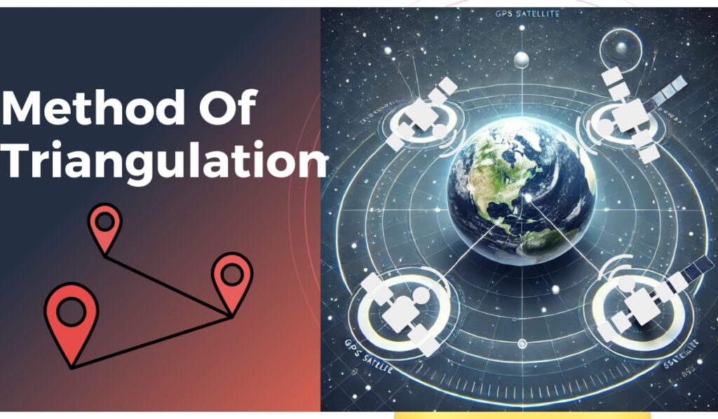
Let me explain trilateration with a simple example of how your GPS device finds your location in a city.
Your GPS receives signals from three different satellites orbiting Earth. Each signal contains information about where that satellite is located and the exact time the signal was sent.
Your device calculates how far away each satellite is from you. It does this by measuring the time delay between when the signal was sent and when it reached your device. This time delay multiplied by the speed of light gives the distance.
Imagine there is an imaginary sphere around each satellite. The radius of this sphere is the distance your device calculated between you and that satellite. Since you could be located anywhere on the surface of each sphere, your actual location is the point where all three spheres intersect.
For example, let’s say:
Satellite A is 20,000 km away from you.
Satellite B is 24,000 km away.
Satellite C is 22,000 km.
Your GPS device creates a sphere around each with these distances as radii. The one point where the three spheres intersect is your location on the ground.
To make this more accurate, your device uses a fourth satellite also. This confirms the intersection point and provides details like your altitude.
As a real example, think you are standing in a park:
Satellite A is right above the park.
Satellite B is over the city centre.
Satellite C is above a nearby lake.
The first three satellites detect you at the park’s edge meeting the city. But the fourth satellite confirms you are actually inside the parking area near its centre.
Components of the GPS Network
The GPS has three main parts – the space part, the control part, and the user part.

1) The Space Part:
You can think of this as the GPS satellites circling Earth. There are usually between 24 to 32 satellites orbiting at any time. These satellites send out signals with information about their exact location and the time the signal was transmitted.
2) The Control Part:
On the ground, there are control stations located in different countries. The main control station is in the US. These stations constantly monitor the GPS satellites. They analyze the data received from the satellites. The control stations also manage the orbital paths and timing of the satellites. If any adjustments are needed for a satellite’s position or clock, the instructions get sent from these ground stations.
3) The User Part:
This refers to any device with a GPS receiver that can detect and understand satellite signals. Examples are your smartphone, car navigation system, or dedicated GPS devices used for mapping and surveying.
Sources of GPS Errors
However, some factors can impact the accuracy when calculating your position:
- 1) Atmospheric conditions like the ionosphere and troposphere layers can distort or delay the GPS signals as they travel through the atmosphere. This affects the distance measurements.
- 2) Multipath errors happen when GPS signals get reflected off surfaces like buildings before reaching the receiver.
- 3) The geometry or positioning of visible satellites in the sky relative to the receiver also matters. Satellites spread out widely give better accuracy compared to clustering closely together.
To reduce these error sources, GPS uses advanced techniques like Differential GPS. This has extra ground stations that provide data to correct for signal errors.
Applications of GPS
GPS technology is used in many different areas of our daily lives, business operations, scientific studies, and security. Here are some key applications:
1) Navigation: The most common use of GPS is for navigation inside car systems, smartphones and other devices. It provides real-time location tracking and directions to millions of users worldwide.
2) Mapping: Surveyors and cartographers rely on GPS to create accurate maps. It is required for precise measurements of the Earth’s surface. This includes mapping for city planning, hiking trails and more.
3) Tracking Systems: In the transportation and logistics industry, GPS tracking is widely used to monitor the location of vehicles and shipments. It helps in optimizing routes, managing fleets efficiently and improving delivery times.
4) Timing: GPS also provides highly accurate time data which is important for financial networks, power grids, telecommunications and other vital infrastructure. The atomic clocks on GPS satellites enable this timing synchronization.
5) Scientific Research: In the field of science, GPS helps in tracking animal movements for conservation, monitoring tectonic plate shifts to predict earthquakes, and other environmental studies.
Conclusion
GPS has changed the way we navigate and understand the world. The constant development of GPS has helped us in our daily lives. Given its wide influence today, GPS technologies are also improving day by day to give us more accurate results than we have today.
